DAY 1: CUSCO – CAPULILLOC – PLAYA ROSALINA
You will be picked up from your hotel around 6:00am, where we will take an approximately 4 hour journey in our private van until we arrive at the starting point for our hike in Capuliyoc (3.150 m/ 10,150 ft.). We will pass through very beautiful countryside as we take in the canyon of Limatambo, the majestic mountain Salkantay and Humantay and several agricultural fields, also passing through several typical villages and beautiful countryside of our region.
After we arrive at the typical town of San Pedro de Cachora, we will take a brief stop to take some photos and continue onward to the starting point of the hike in Capuliyoc. Here we will wait our muleteer with our mules and horses that we start this wonderful adventure and be able to take the first pictures of the Canyon of the Apurimac. After getting ready, we will begin our journey down a narrow road for about 3 hours to Chiquisca, where we will have lunch and enjoy a fantastic view of the Apurimac Canyon as well as Padreyoc Mountain, and the location of Choquqequirao. Afterwards, we will resume our hike for a couple of hours where the climate is significantly warmer and flora and fauna begin to change. Finally we arrive to our camp in Playa Rosalina (1,550 m), beside the Apurimac River “God Speaker,” delicious lunch awaits us and we spend the night in this location.
- Food: Lunch and dinner
- Accommodation: camp
- Maximum altitude: 3,150 m / 10,150 ft
- Minimum height: 1.550 m / 5,085 ft
- Distance: 10 km / 6 miles
- Approximate hiking time: 6 hours
- Difficulty level: moderate.
DAY 2: PLAYA ROSALINA – MARANPATA – CHOQUEQUIRAO
To start the, day we cross the River on a footbridge and here we will ascend early to climb the steep zigzagging path, 5 hours depending on your physical condition, but don’t worry if you feel tired or a little agitated. We have an emergency horse which can be used to continue our journey. Along the way we will see many orchids considered the most beautiful wildflowers, as well as a variety of birds, and see the entire area of the Canyon surrounded in its vegetation and environment. We will have lunch at Maranpata, where our chef will be waiting with a delicious lunch to replenish the lost energy. The afternoon hike will not be very steep, and it will be about 2 hours until you reach the archeological site where we will camp in a flat area nearby- In the afternoon we will enjoy the sunset of this enigmatic place and have a nice dinner.
- Meals: Breakfast, lunch and dinner
- Accommodation: camp
- Maximum altitude: 3,035 m / 9.957 ft
- Minimum altitude: 2.800 m / 9.186 ft
- Distance: 11 km / 6.82 miles
- Approximate hike time: 7 – 8 hours
- Difficulty level: difficult
3er DIA.- CHOQUEQUIRAO – RIO BLANCO – MAIZAL
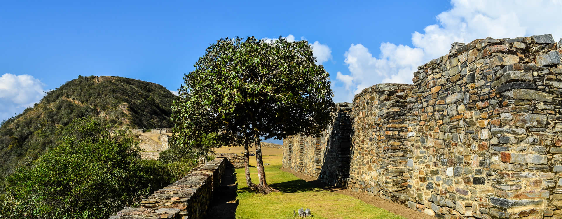
On the third day we will have breakfast early and visit the archaeological site of CHOQUEQUIRAO, where we will be able to watch the sunrise and later have a guided tour of the archaeological zone. We will continue our hike which is very heavy and ascend almost all day. We will pass through the sector of RIO BLANCO, where we will have lunch on the banks of the river. After having a short break, we will continue onward about 3 hours to arrive at our camp in the Maizal sector.
- Meals: Breakfast, lunch and dinner
- Accommodation: camp
- Maximum altitude (CHOQUEQUIRAO Pass): 3,270 m / 10,728 ft
- Minimum altitude: 3,000 m/ 3,842ft
- Distance: 17 km / 10 miles
- Approximate hike time: 7 – 8 hours
- Difficulty level: difficult
4th DIA.- MAIZAL – MINAS VICTORIA – YANAMA
After taking another early breakfast, we will ascend for about 4 hours, skirting the Yanama pass, then descend and make a brief stop at Victoria mines. From here we can appreciate the flora and fauna of the area, as well as some valleys and stone blocks that contain minerals in abundance. Today the mines are completely abandoned, We will have lunch in this area and take a short break before descending again until we reach our camp in Yanama.
- Meals: Breakfast, lunch and dinner
- Accommodation: camp
- Maximum altitude (San Juan Pass): 4,200 m / 13,779 ft.
- Minimum altitude: 3.522 m/ 11,555 ft
- Distance: 14 km / 8.68 miles
- Approximate hike time: 7 hours
- Difficulty level: difficult
5th Day.- YANAMA – TOTORA – COLLPAPAMPA
On this day the hike will be moderated by the geography of the terrain, as well as appreciate the diverse landscapes to reach the highest point to the Mariano Llamoja pass, where we will appreciate the majestic mountain ranges and can see the glaciers of Salkantay and Humantay in the distance. Then down some slopes, we will see the great biodiversity of the area. Continuing down the trail, we reach the place of Totora where we will have lunch, and then continue our journey for about 3 hours to get to the camp COLLPAPAMPA. Here some of the settlers sell drinks, batteries and other items, dinner and rest.
- Meals: Breakfast, lunch and dinner
- Accommodation: camp
- Maximum altitude (Mariano Llamoja Pass): 4,660 m / 15,288 ft
- Minimum altitude: 2,900 m/ 9,514 ft
- Distance: 18 km / 11 miles
- Approximate hike time: 9 hours
- Difficulty level: difficult-moderate
6th Day.- COLLPAPAMPA – PLAYA – LUCMABAMBA
After having breakfast, we will leave by 6:30am where we will pass through narrow trails with abundant flora and fauna of the region as well as appreciate what are considered to be some of the most beautiful orchids and enjoy beautiful waterfalls of this area is known as ceja de selva (sub- tropical climate). After hiking 5 hours, we arrive in LORETA, where our van will be waiting to take us about 45 minutes to have lunch at our camp. Passing through the village of (SAHUAYACO or Beach), we will finally arrive at our camp at LUCMABAMBA. Here we will have our traditional lunch.
In the afternoon we will be able to visit a local family for a demonstration of the coffee process, as well as appreciate the coffee plantations and some other varieties of fruit trees in the area.
- Meals: Breakfast, lunch and dinner
- Accommodation: camp
- Maximum altitude: 2,900 m / 9,514 ft.
- Minimum altitude: 2,130 m/ 11,979 ft
- Distance: 17 km / 6.988 miles
- Approximate hike time: 6 hours
- Difficulty level: moderate
7th DAY.- LUCMABAMBA – HIDROELECTRICA – AGUAS CALIENTES
From approximately 7: 00 a.m. we begin to hike about 7 hours along the Inca Trail to the hydro-electric dam. Enjoy the beautiful landscape along the way, as well as the vast flora and fauna of the sector. After approximately 3 hours of climbing, we reach the peak of Puncuyoc, then we descend to the archaeological site of Llactapata, where you can see the Inca Citadel of Machu Picchu. After descending for about two hours we will appreciate the fruit plantations of the Aobamba Valley on the way to the station at the hydroelectric plant. Lunch will be at the dam site, and then we can board the train in the afternoon, which will take us heading to Aguas Calientes, where we overnight at the hotel, dinner and rest.
- Meals: Breakfast, Lunch, Dinner
- Accommodation: Camp
- Maximum Altitude: 2,815 m / 12,600 ft.
- Minimum Altitude: 1,830 m/ 6,003 ft.
- Hike Distance: 14 km / 8 miles
- Approximate Hike Duration: 7 hours
- Level of Difficulty: Moderate
8th DAY- AGUAS CALIENTES – MACHUPICCHU – CUSCO
Here we will have breakfast at the hotel, then board the bus that will take us to the Citadel of Machu PICCHU where we will have a guided tour for about 2 hours. Afterwards, we will have free time to explore and be able to go to the INTI PUNKU (door of entry to the Citadel) to take panoramic photos from this area. In the afternoon we will take the train back to OLLANTAYTAMBO and then collect you by bus and return to the city of CUSCO, arriving in the evening.
- Meals: Breakfast
- Maximum Altitude: 2,440 m / 8,038 ft
- Minimum Altitude: 2,040 m/ 6,725 ft
- Hiking Distance: 8 km / 4 miles
Discounts:
- Student discount (only with an active green ISIC card) US $20.00
- Under 15 years old pay as a student: US $ 20.00
- Under 7 years old discount: US $ 35.00
AVAILABLE FOR RENT
- Walking Sticks $ 20.00 USD (pair) for the entire trip.
- Sleeping Bag $ 35.00 USD
- Private Tent $ 40.00 USD
- Horse to ride for the entire trip $ 170.00 USD
Includes:
- Transportation from Cusco – Cachora – Capuliyoc (start of the hike).
- Cook
- Muleteer (Mule Handler)
- Baggage allowance of 7kg per person
- Pack horses for camping equipment and food
- Emergency Horse
- Train ticket from Hidroelectrica – Aguas Calientes
- Return train ticket Aguas Calientes – Ollantaytambo (Expedition Train)
- Admission ticket to the citadel of Machu Picchu
- Admission ticket to the Choquequirao archeological site.
- Pillow and blanket just for the hike.
- Bilingual guide (English-Spanish) for the entire trek
- Meals: 07 breakfasts, 07 lunches, 07 dinners.
- Bus fare up to Machu Picchu
- Bus from Ollantaytambo – Cusco
- One night hotel with private bathroom and hot water
- Camping equipment: 2 or 4 person tents (depending on your required accommodation), mattress, dining tent, kitchen tent, chairs, tables, menagerie.
- First Aid equipment, oxygen tank, first aid kid and emergency radios.
- VEGETARIAN OPTION AT NO ADDITIONAL COST.
Other: For hikers with cargo or excess baggage, we have mules or extra horses for rent for 5 days at a cost of $160.00 USD (Recommended).
Note:
Times depend a lot on the train schedule you are given. You have to arrive at least half an hour before your train’s departure at the station. Rates are subject to any increase or readjustment as determined by the Ministry of Culture and PERU RAIL S. A (railway company).
What you should take:
Passengers should carry the following personal items:
Travel insurance, personal items, first aid kit, fever/ upset stomach/altitude sickness pills, water purifier, sunscreen, mosquito repellent, rain ponchos, canes, hiking boots, camera, cap for the sun and the cold, thermal clothes for in the night and light clothing for the day, money (at personal discretion) and original documents: Passport, DNI, and for students, their original ISIC card.